Garmin Standard Mapping® - Texas East Classic microSD™/SD™ Card
Regular price
$231.44 CAD
Sale price
$231.44 CAD
Regular price
$231.44 CAD
Save 0
-
Estimated Delivery :Jun 09 - Jun 13
-
Transit Time : Transit Time for this product is around 2 - 4 days.
Garmin Standard Mapping® - Texas East Classic microSD™/SD™ Card
Regular price
$231.44 CAD
Sale price
$231.44 CAD
Regular price
$231.44 CAD
Product description
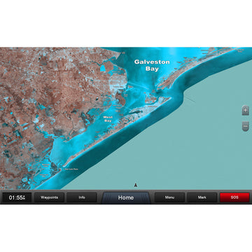
Standard Mapping® - Texas East Classic microSD™/SD™ Card
Statewide coastal aerial overlay provides high-resolution imagery and local names of waterways and land features.
High-resolution Aerial Imagery
Replaces the basemap so you can see every waterway and land feature.
High-definition Offshore Mapping
High-contrast offshore elevation shading allows you to easily see detail.
Local Names
Identifies local waterways and land features.
 WARNING: This product can expose you to chemicals which are known to the State of California to cause cancer, birth defects or other reproductive harm. For more information go to P65Warnings.ca.gov.

Latest News + Exclusive Offers
Top Brands